Wednesday, September 25, 2013

Mining in the Mohave Desert

It wasn't easy to get things to Kingman, Arizona back in the day - especially heavy mining equipment.  And once the ore was excavated, it wasn't easy to get it to processing plants and then to "market."

Before the railroads made it west, supplies had to come by ocean steamers from San Francisco, down and around the tip of Baja California - over 1,900 miles! - then up the Gulf of California to the mouth of the Colorado River near Yuma, Arizona.  It was then off-loaded onto paddle-wheelers and carried another 300 miles north to Parker and Hardyville.  From those docks, supplies were put into wagons and onto backpack mules to carry across the desert to the many different mining camps.


Where there was room enough for two horses or mules to pull side by side, wagons would take over.  But wagons were hard to control going down a mountain and could be too much of a load for a team to pull up a mountain.

The wagons were so heavily loaded that they wore these tracks into solid rock over a period of 30 or so years.  The divots you see in the side of the rock here on the White Cliffs Wagon Road are where teamsters would place poles used to help push the wagons along much like longshoremen did on rivers, or to help hold a wagon back if they were headed downhill.  There's speculation that one man cleared this particular area to create a "road" and then charged a toll for folks to use it.  Each day he would have to travel the road to clear the rocks and debris from the path.

All of that effort against the trials and tribulations of nature - AND they were subject to Indian attacks, too.  An all-out war between the Hualapai and miners raged from 1866 to 1871.

Millions of dollars in precious gold, silver and other minerals such as turquoise, molybdenum, galena (a by-product of lead and silver now used as the semiconductor for wireless sets) and silver chloride (used in the relatively new art of photography) were taken from the Mohave County earth.  One year, from July, 1889 to July of 1890, nearly $1 million ($25 million in today's currency) of ore was hand chiseled from these mountains of rock.  That's what made it worth the price (physical and fiscal) to haul things by sea and by land to the Kingman area and the ore back out.

There was always some refreshments waiting for the miners in Kingman, though.  This "billboard" for a Kingman saloon is still visible on the side of the toll road!  (Sure wish today's paint would last as long as this guy's did!!)

But eventually the railroads did make it to the area.  The A & P (Atlantic and Pacific) in 1883, and by 1899 a single spur made it's way from Kingman to Chloride, Arizona.  That spur became known as the CB&F: Chloride Back & Forth.  By 1900, there were over 2,000 miners working 700 claims around this area, and the city of Chloride was coming of age.  They put an ordinance in place:  No person shall appear in a public place naked or in a dress not belonging to his or her sex.  Yes, time does tend to tame us all, eh?
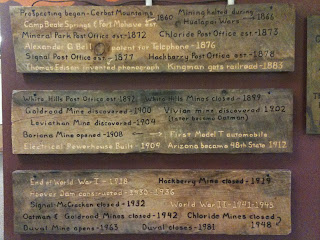
From 1900 to 1919 the Goldroad Mine in the Oatman area, discovered when a man went looking for his lost burro, gave up over $7 million dollars worth of gold (about $175 million in today's dollar).  The government closed this mine and many others like it in 1942 because they weren't considered vital to the World War II "effort."  It seems that Molybdenum was in much greater demand to carry out the industrial functions of World War II.  Nowadays, it is far more valuable than even copper!!  "Moly" is alloyed with iron to make things like hard, high speed cutting tools.

You might also be interested in mining in the Grand Canyon:
http://thetravelerstwo.blogspot.com/2013/09/mining-at-grand-canyon.html


and in the southeastern part of Arizona:
http://thetravelerstwo.blogspot.com/2013/11/mining-around-tombstone.html 


If you like our blog, you can "subscribe" for free by clicking on the broadcast icon at the top right corner or by bringing out the right hand toolbar and clicking on that icon at the bottom of the list.  It will put that icon on your toolbar at the top of your browser screen.  I try to post every day - it'd be a shame for you to miss one!  On your iPhone, you can create an app by "adding to home screen," bookmark it, or add it to your Reading List, share it on Twitter or Facebook.  Any way you do it, it's free!
 

Tuesday, September 24, 2013

Winchester 73 - Forever Faithful

 
There are several stories that go with this relic we discovered in the Kingman Museum.  The most likely to me, because the Kingman, Arizona area was settled by miners, is that  this Winchester 73 was placed in the notch of a tree with a trip wire as a silent guard for the miner's claim.


This version was even reported in Ripley's: Believe It or Not, and The Winchester Proof (December, 1955).  I don't know about the man that owned it, but it seems to me that the Winchester 73 never gave up its vigil, huh?

Monday, September 23, 2013

The Lord's Prayer

Have you ever had some much to pray about you simply don't know where to start, or a heart so heavy that it's impossible to find the words necessary to lift things up to the Lord?  God knew that would happen!  So He gave us this simple prayer:

  9 Our Father which art in heaven, Hallowed be thy name.
 10 Thy kingdom come, Thy will be done in earth, as it is in heaven.
 11 Give us this day our daily bread.
 12 And forgive us our debts, as we forgive our debtors.
 13 And lead us not into temptation, but deliver us from evil: For thine is the kingdom, and the power, and the glory, for ever. Amen.

The Lord's Prayer, King James Version (KJV) Matthew 6:9-13

I was in a life threatening situation with my three young children once.  There was no safe way out.  The only thing that came to mind was this prayer - and I prayed it over and over and over until help came - through a very different stranger.   I must have witnessed to him, though I don't remember ever using any particular words.  Turns out, he was being indicted for a white collar crime and spent a couple of years in jail.  One evening the phone rang and his mother introduced herself.  She said that he had just committed suicide, but had asked her to find me if anything happened to him, and to let me know.  I was stunned, to say the least, about the news, and that our chance encounter several years before had left such an impression.  I believe God's hand was in it all, and that it was God who witnessed to him somehow through me.

The Lord's prayer is a powerful, powerful prayer.  They are God's own words, so of course they'd be powerful!  But they are ours to use when our own minds fail us.  They are so familiar that it's like a healing balm when they are said out loud.  These words say it all...

The Graffiti House at Brandy Station

The armies of two determined men, Confederate General Lee and Union General Hooker, clash.  With relatively few infantry, but 10,000 horses and men each, they engage in the largest cavalry battle the Western Hemisphere has ever seen.

They charge each other on Fleetwood Hill, firing their guns on the first sighting of each other, but then there's no time to reload, and so it becomes a bloody battle of hand-to-hand sword and bayonet fighting. Even after exhausting his men and horses the day before with parade-charging practices and a review of troops for General Robert E. Lee himself, and after being surprised by Union General Hooker's men, twice!, Stuart salvaged the day.  He maintained the field of battle (with the help of a rain and hail storm) suffering "only" 575 casualties.  The Union lost 866 men.  But the Confederate cavalry had lost its superiority for all time that day.

You can read a play by play detail of the battle which began at Beverly's Ford on the Rappahannock River at http://www.nps.gov/frsp/brandy.htm, but this blog post is really about a home built in 1858 but is now known as The Graffiti House.

This is the house as it stands this day:


When we open the door, we don't see much, but then again, it's the headquarters of the Brandy Station Foundation, not just a museum piece.  It's a work very much in progress.  It's a room like many other rooms, the floors look new (and are), the walls are completely absent graffiti and looking new, there are tables and shelves and a scattering of photos and presentation boards.  Not too impressive.  But there is a wonderful ol' gentleman who reminds us of Ray Russell, our Sunday School teacher back home.  Ray's from Maine, and we find out that this man is from Pennsylvania - but they sure look alike!

I ask him to tell us the story, and so he begins.  He's very, very good at talking story.

First, to understand where the Foundation has come from he explains the recent history.


The owners of this house were planning a community event around the burning down of this place.  They had a city permit, had the fire department standing by - it was gonna be a real small town to-do.  Dad told his sons to go in one last time and make absolutely certain every possible piece of something to salvage had been removed.  They noticed a piece of paneling nailed to one of the  walls upstairs and decided, what the heck, let's take it.  What they saw on the wall behind the panel put their little event on hold - permanently.


Can you make out the initials and last name?  "J.E.B. Stuart"  And that's just the beginning.  Under layers and layers of paint, hundreds of names, initials, and drawings have been discovered.  All of the downstairs graffiti apparently was cut out in the dark of night and sold before something could be done to stop it.  What is left is upstairs.

The Brandy Station Foundation was formed, and they have struggled for decades to preserve the structure and the marks left by injured soldiers from both sides - and their caregivers like poet Walt Whitman who came there to find his wounded brother.  Whitman found him, nursed him back to health, shipped him home to their momma on a train, but stayed himself to tend to others until all had left Brandy Station.

The writings and drawings are believed to be one of the most extensive collections of Civil War graffiti discovered in recent decades.  They were mostly done in charcoal taken from the fireplaces, but some were done in lead pencil.  This means that the drawings have not faded and will not fade - so flash photography is not a problem if you want to snap a picture!  (That's a novelty in itself!)

July 21, 1861, after the first Battle of Manassas, this house was used as a hospital for retreating soldiers.  It was used again in 1863 after Confederate General Richard S. Ewell and Robert E. Lee observed part of the Fleetwood Hill action - which almost made it to the house itself.  The home's owner at the time, James Barbour, was actually on Ewell's staff.

The Foundation has identified many of the names on the walls and put their stories together. 


Michael Bowman was a member of Company H of the 7th Virginia Cavalry.  He enlisted in the Confederate Army April 18, 1861 in Harrisonburg, Virginia.  He was wounded in the fighting at the Wilderness May 5, 1864 but did recover, survive the war and return to his house near Harrisonburg, Virginia.

These initials are identical to those drawn by George Armstrong Custer, but he usually included an "A," so the Custer folks won't officially confirm these belong to him - though they confess they are drawn identically...


 This is an accurate date for the first snowfall of the 1863 winter...  November 9th, 1863.

 
Removing the layers of paint is (thanks to the Federal laws and EPA rules) very, very expensive.  The Foundation can only afford to do this in little bits.  It costs hundreds of dollars an hour for this specialist to come in.


This is the most historically significant piece of graffiti in the collection:  The Maryland Scroll.  A member of the Rifle Gun #1 of Breathed's Battery, Stuart Horse Artillery drew this.  It lists the entire crew of Rifle Gun #1, and includes the inscription, "On picket, March 16, 1863."  The next day is when the Brandy Station battle began.  Why, might you ask, is this in a display case?  It is one of the pieces that was sold to a private collector.  The Foundation was able to raise the money necessary to buy it back.

The stories are too many to tell here.  You really should go see this for yourself.  And if you appreciate what you have read and learned here, if you go yourself to see more, I truly hope that you send a donation to the Brandy Station Foundation so that they can continue their incredible work.

Tuesday, September 17, 2013

Critters of The Canyon

I suppose the earliest record of critters found in the Grand Canyon is a pile of poop.  Mmhmm.  Poop.  Seems there's a cave there that is chock full of giant ground-sloth dung "deposited" there during the Ice Age.  One park ranger back in 1920 thought that was pretty cool, so he brought a pile home and tried to display it on the top of his wife's piano.  Is it any surprise that she said, "No!"

Currently the Grand Canyon boasts a family of albino bighorn sheep, jackrabbits that run up to 40 miles per hour, Gila monsters (big AND poisonous)... but the most poisonous critter is the red ant.  Now, granted, one bite won't kill you, but get a swarm of 'em, and you won't be feelin' so fine.

The tarantulas may be the scariest, but they are the least dangerous.  Not so, the pink rattlesnake!  However, in 1929, a brave park ranger, finding the first one he'd ever seen, grabbed the lil' feller behind the head (the only safe place to pick one up), and hiked up out of the canyon to his car.  Not finding anything to put it in, he simply held his arm out the window and drove home with his prize.  (Since automatic transmissions weren't around until the 1950's, that was probably a pretty crazy trip!)

There are bats.  Caves = bats, eh?  The smallest bat in the canyon is the western pipi-strelle.  They may be small, but they are no slouches when it comes to having babies: the pipistrelle is one of the few bats that give birth to twins.  Bats are the only mammals that are capable of true flight, too.  Bats to whales.  Mammals cover a wide spectrum, huh?

Of, course I've already told you about the condors that have been reintroduced to the canyon.  Today's condors can be found nesting in the same caves their ancestors used 12,000 years ago during the Ice Age!  That's cool on several levels!  (They know that fact because they carbon-dated a condor skull they found there.)  That may be the ONLY cool thing about condors, however!  They eat only rotting dead things, have bald heads because the dead goo doesn't stick to bald as bad as it does to feathers, and they pee on their own legs as a way to cool off in the summertime.  Eewww!

You know what?  I think we should go back to Virginia where everything isn't so ... western!


Monday, September 16, 2013

The Squirrelly Grand Canyon

If you think this guy is cute...

 
you should see him in the wintertime when he has tufts of hair growing off the top of his ears.  Utterly adorable!!  I love his polka-dot fur.
 

The Kaibab squirrel is a subspecies of the Abert squirrel.  The Kaibab is endemic to a 20 - 30 mile area of the north rim of the Grand Canyon area.  It's the only place in the world that you'll find this guy!  Seriously?  On this entire, humongous planet this is the only teeny-tiny spot that you can find this squirrel?  Cool!

The Abert is concentrated in the Arizona, Grand Canyon, New Mexico, and southwestern Colorado area, but can be found south into Mexico and up into the Rocky Mountains.  They were named for Colonel John James Abert, an Army topographer from the 1800's who organized the effort to map the American southwest.  (Talk about a tall order!)

Both the Abert and the Kaibab eat pine nuts - and the hawks eat the squirrels!!


Saturday, September 14, 2013

Daniel Boone

Daniel Boone (1734-1820) learned his woodsmanship from his dad who gave Daniel his first rifle when Daniel was only 12 years old.  Soon after that Daniel shot his first bear.  Daniel's dad, Squire Boone, was a blacksmith and weaver.  (Now there's an unlikely combination!)

In 1749, when Boone was 15, he and his family picked up stakes and moved to Rowan County, North Carolina, on the Yadkin River.  Being an enterprising young man with skills, he started his own hunting business.


In 1755, during the French and Indian War (that's the French and the Indians ganging up on the English colonists to run them out of North America), Boone served as a wagoner for British Brigadier General Edward Braddock in the Battle of the Monongahela in an attempt to capture the French Fort Duquesne (now known as Pittsburgh, Ohio.)  The French prevailed, and Daniel only got away because of his well-honed survival skills.  He also got away on one of those horses he used to pull his wagon!

In 1756 he married, saying, all a man needed was "A good gun, a good horse and a good wife."

In 1769 I guess Boone made the discovery of his lifetime, the one he's truly remembered for.  He led an expedition of four men on a "boys trip out," Boone found the now famous Cumberland Gap through the mountains to the North American west.  In 1775 he packed up his family of wife and six children, moved through the Gap, and carved a settlement out of the wilderness named Boonesboro.

Now, folks, if you think it was all roses, think again.  We are truly talking wilderness and hostile Indians.  Boone even had one of his daughters kidnapped by the Indians!  Boone, being the man he was, stole her back, but this was no easy move he and wife Rebecca made.  I just don't know if they make families like theirs anymore - or ever will again!  We are all pretty much wimps nowadays.  In the years that followed, Boone was shot in the ankle during an Indian attack and even captured himself by the Shawnee!  Finally, all the settlers got their money together, gave it to Daniel, and he set out to buy land permits.  (Wait a minute.  The Indians owned the land, Daniel fought for the land, but now he has to BUY permits from the British to live on it??  The arrogance of government never ceases to amaze me.)  Poor Daniel got waylaid by thieves who took everyone's money.  Nothing in life is simple...

In 1780, Daniel fought with Colonel George Rogers Clark (brother of William Clark of Lewis and Clark fame) in the Battle of Piqua during the American Revolution (1775- 1783).  Strangely enough, the Battle of Piqua was the largest military engagement of the American Revolution west of the Allegheny Mountains, but for some weird reason the history books give no mention of it. 

First, Clark planned to secure a supply location.  This was accomplished (where Riverfront Stadium is located today in Cincinnati!), and Clark left Daniel there to guard the supplies.  (Remember, an army travels on its stomach.)  Then Clark and his forces moved on to Chillicothe, Ohio.  (This is significant to our family because our mother was born in Chillicothe, Texas - namesake of Chillicothe, Ohio.)  The battle took place here against the British-supported Indians.  Their 4,000 strong force stood against Clark's 1,000 men.  The colonists prevailed because they weren't just fighting the Revolution, but they were also trying to stop the British-supported Indians from sneak attacks against their homes and families. Well, that and Colonel Clark's superior tactics.

In 1788 Boone and his family moved north to Point Pleasant (now in West Virginia) where he served as a lieutenant colonel and county legislative delegate.  Later he moved one final time west into Missouri.  He spent the rest of his life doing what he loved most - hunting.


The Rim of the Kaibab Plateau

As we leave the Interstate headed north out of Williams, Arizona, the road begins an ascent that doesn't stop for 60 miles!  If you want to bicycle the Rim, I suggest you put the bike in a car, drive to the Rim and THEN start pedaling!  Otherwise you'll be all tuckered out before you get halfway there.


The National Park Service has really done a beautiful job of making access up and down the south rim easy and gorgeous.  (Yes, that's me.) Staying on the path is important because the vegetation really is fragile.

The Colorado Plateau and the Rocky Mountains were uplifted by the same geological forces at the same time.  The Kaibab Plateau is the southern part of the Colorado Plateau and can reach heights of over 9,000 feet.  That explains why it's been known to snow on the rim in July!  We didn't experience snow, but we did see the results of a hail storm that passed by just minutes before us:


Some areas of the Kaibab can get 200 inches of snow in a single season.  Folks apparently do a lot of back-country Alpine skiing and snow camping up here.  Believe it or not, there are about 1,500 Park employees that live on the South Rim year-round.  (I wish I'd known these things when I was 20!  I woulda moved here in a heartbeat.)

Lots of people don't pay much mind to the rim, but I heard tell of a couple who left the Park only to turn around in minutes and come back to the entrance, explaining that they had gotten so caught up in the beauty of the rim that they'd forgotten to look at the Canyon!  I can't imagine that!


Friday, September 13, 2013

Grand Canyon National Park and World Heritage Site

The Grand Canyon is not only a United States National Park, but it is also a World Heritage Site.  What does that mean?

Well, the United States was the first nation ever to formally establish and protect unique locations as national parks with the concept that they should never be exploited for economic gain.  They should belong to all citizens, forever unblemished by development.  Yellowstone was the first in 1872; Grand Canyon National Park came along in 1919.


With 70 miles of views like this from paved roads on the south rim alone, can't you just imagine the hoteliers that would want to build lodges all along the rim?  Then you'd have to have fast food restaurants and gas stations and...and...and...  Elected officials would vote yes because all of that means tax dollars into government coffers - from local to state to national levels they would vote yes.  But because back almost 150 years ago, someone played the statesman and said, "No!"  (That would be Teddy Roosevelt - the REPUBLICAN Roosevelt), we have fabulous, God-made national treasures!

Well, in 1954, Egypt decided it needed to build a dam, and that dam would flood treasures of ancient Egypt.  Hey!  They belong to Egypt!  Shouldn't Egypt be able to do what they need to for the living Egyptians? 

The world as a whole was made aware of what Egypt was planning by UNESCO (the United Nations
Educational, Scientific and Cultural Organization.)  There was a compromise between Egypt and the world that allowed for the Aswan Dam to be built - but only after UNESCO countries paid to have The Abu Simbel and  Philae Temples taken apart, moved to a higher location, and put back together piece by piece, the Temple of Dendur was moved to Metropolitan Museum of Art in New York City, and the Temple of Debod was moved to Parque del Oeste in Madrid.  (Only $80 million in 1954 dollars.)

One thing led to another and the Convention Concerning the Protection of the World Cultural and Natural Heritage was adopted by the General Conference of UNESCO in November, 1972.  The Convention came into force in December, 1975.  As of June, 2013, it has been ratified by 190 states, which includes 186 UN member states plus the Cook Islands, the Holy See, Niue, and Palestine in Israel.  Since that time, twenty-one sites in America have been designated as World Heritage Sites:

Mesa Verde
Yellowstone
Glacier Bay in Alaska
Grand Canyon
Everglades
Independence Hall in Philadelphia
Redwood National Forest
Mammoth Caves
Olympic
Cahokia
Great Smoky Mountains
San Juan National Historic Site in Puerto Rico
Statue of Liberty
Yosemite
Chaco
Hawaii Volcanoes
Monticello
Taos Pueblo
Carlsbad Caverns
Glacier (our only "National" park to actually be an International Park from its inception)
Papahānaumokuākea Marine National Monument (140,000 square miles!) in Hawaiian waters

Granpa and I have been to over half of them!!

There are a dozen or so more "tentative" sites.

Well, that's a least ONE good thing the United Nations has done.  (I think.  Maybe.)


Thursday, September 12, 2013

Into the Grand Canyon

Wouldn't it be great just to drive down into the Grand Canyon?


I suspect the reason the National Park Service hasn't built roads down into the Grand Canyon (besides the extraordinary cost financially and environmentally) is that it would invite the average person down.  That would magnify the dangers exponentially.  Can you imagine being down in the Canyon when this cloud burst opened up?


Even so, back in the 1960's a highway map published by the American Automobile Association (AAA) represented hiking trails as highways and people came from all over looking for a way to drive in!

But again I say, you don't have to take but a few steps from your car to the rim's edge to make the trip well worth your while.  With a pair of average binoculars you will even be able to see at least five famous rapids of the Colorado River:  Hermit, Granite, Hance, Unkar and Lava Falls.  Hermit Rapid sports some of the largest waves on the river - up to 15 feet! - but they're not as chaotic as Granite Rapids.  If you're "scoping" out Unkar Rapids be sure to look for rafts tied up to the shoreline.  Their occupants are probably checking out the Ancestral Puebloan ruins on the Delta there where the ancients farmed.  (Farming down inside the Grand Canyon.  Can you imagine?!)

From the North Rim, if you go west for a couple of hours, you have a chance to see Lava Falls Rapids which is one of the most famous of the Colorado's canyon-run rapids.  Even 30-foot motorized rafts have flipped over in this cauldron of hydraulics!  They say that there are only two kinds of river guides in the Grand Canyon:  those who have already been flipped by the river, and those who are going to be flipped.  And you only have to pay about a thousand dollars a person for the privilege!


Wednesday, September 11, 2013

The Grand Canyon

The finest and most spectacular views of the Grand Canyon are NOT from the south rim or the north rim.  The finest and most spectacular views are seen from the inner-canyon trails. 


The trails are carved out of the sides of the cliffs!  You can hike 'em or catch a mule ride!  On the right side of the picture below, find the "block" formation.  Follow it back to the lower right corner.  That's a trail with people on it.  Can you see them?  Distances are deceiving, yes?


There are hundreds of small ancient Indian ruins of pueblos in the canyon and on the rims.  The Tusayan Ruin and Museum is the easiest to get to.  It's a few miles inside the east entrance to the Grand Canyon National Park.

Remember, if you or a passenger in your car is 62 or older you can get a Golden Age passport and get into ALL National Parks for free!  Disabled vets, too. 

  • Senior Pass ($10.00 - valid for the lifetime of the pass owner; must be 62+ older, U.S. citizen, and a permanent resident)
  • Access Pass (Free for lifetime with documentation of permanent disability, U.S. citizens and permanent residents)

  • The South Rim drive is 70 miles long and open year-round.  You're just a few steps from the edge of the canyon, so even non-hikers get spectacular views!  The elevation is 7,000+ feet, so it's cool enough even in the summertime!

    Tuesday, September 10, 2013

    A Cloudy Day Doesn't Matter at the Grand Canyon


    It was very, very cloudy at the Grand Canyon with some occasional rain and wind.


    But then the clouds would begin to clear a bit.


    Granpa always says not to let a cloudy day stop you from taking pictures.  In fact, most of the time an overcast day can give you some of the best pictures because there is no glare from the sun.  Sometimes too much sunlight can wash colors away, too.


    The clouds helped to see the outlines of particular formations one might miss if the whole vista was uncovered.  Again the clouds disappear, and the canyon is revealed.  Now you completely miss the same formation, don't you?


    Saturday, September 7, 2013

    I Have A Praise!

    I have a praise.  After my post about our son's pain, you guys must have sinned a bit less because yesterday the Social Security Administration notified him that he has been approved for disability payments.  A man not being able to make a living for his family causes men great pain.  This disability payment is not something our son earned, it's something that he's been paying taxes for all his working years - since being a newspaper boy in Palestine, Texas at the age of 12 until earlier this year when his spirit and pride finally broke and he had to apply.  I praise God for our son's being approved, and I thank you guys for sinning just a little bit less!

    Friday, September 6, 2013

    The Bible

    For those who feel lost when you pull a Bible out because you have a worry and don't know where to start in the Bible - anywhere will do. There's something about reading the Word that brings peace. BUT, a little help here: the first five books of the Old Testament are the books of Jewish law (which was impossible to keep so God sent Jesus), the next twelve books are about the history of the Jewish people, THEN you get to the books you are probably looking for: the Job, Psalms, Proverbs, Ecclesiastes, and Solomon, the major prophets are awesome: Isaiah, Jeremiah, Lamentations, Ezekiel, Daniel, but the twelve minor prophets are important, too. That is all there is to the Old Testament: Law, History, Wisdom, Major and Minor Prophets. Does that help?

    The New Testament is even simpler: the first four Books are called The Gospels and tell of the life, death, and resurrection of Jesus. They all tell the same story, but they are written by four different men (Matthew, Mark, Luke and John); the next is known as Acts about the history of the Christian church and the spread of Christianity; the next nine are letters written to new Christians groups or churches in different towns like Corinth, Galatia, Ephesus... That is followed by letters written to individuals. If you're a new Christian these two groups would be pretty cool to read. And it ends with the virtually impossible to understand Book of Revelations. Revelations is so full of imagery you need to take a class on it!! Don't go there for awhile, but when you get there, it is magnificent.

    Our First Visit to the South Rim


    I thought Granpa was taking a picture of me with his cell phone.  Turns out he was taking a picture of himself.  I guess he was impressed that he finally made it to the south rim of the Grand Canyon.  Years ago we stopped off at the north rim, but Granpa's dad was with Roosevelt's CCC (Civil Conservation Corps) back in the 1930's when they built the Bright Angel Trail down to the Colorado River from the south rim.  (We always tell folks that Daddy John helped build the Grand Canyon :)  Granpa has always wanted to get to the south rim.  Unfortunately, when we finally made it, we are too old to take the trip down the Bright Trail.

    This is the same picture sans Granpa:


    Not bad for a cell phone picture, huh?


    So, all in all he took something like 512 pictures.  No, we're not gonna make you suffer them all.  The clouds just kept changing the view, and it was mesmerizing.  A lot of these views Granpa got while we were juggling umbrellas and fighting the winds coming up the side of the canyon.


    But to set the stage:


    There are several miles of paved trail along the rim going east and west from here.  At this spot is the main Visitors Center, restrooms, geedunk, and gift shops.  In the Visitors Center the first thing we see is an amazing motion picture presentation.  If you ever get to the south rim, be sure to see this!


    We were also told to watch for this dude:


    No offense, but this is not a handsome man.  Can this be a real creature?  Yup, it is.  And what's that sticking out of his chest feathers??  He is definitely a funky lookin' feller!


    Wednesday, September 4, 2013

    My Son's Pain

    I was on my knees just now, praying to God and asking him to stop our sons pain.  Don't even fix the injury - just stop his pain.  A vision flashed into my mind of God sitting on His throne in heaven, looking down on me with enormous empathy and love.  Empathy means that He truly understands my grief.  I felt Him say, "Who is there to help My Son in His pain?  Even after His death on the cross for the sins of man, mankind still sins."  He said this with great love and kindness to let me know that He understands my grief.  Will He stop our sons pain?  I don't know, but I do know that He understands.  Maybe, just maybe, if you and I sin a bit less today, my son's pain will be a bit less.

    Tuesday, September 3, 2013

    Syria Suggestion

    If you want to help the Syrian people, donate money to your Christian disaster organizations that might be helping out over there. We should always turn to the Lord and not government when things are as confused and conflicted as the Syrian situation is. Pray for wisdom for America's political leaders, too, but don't send them any money.

    Monday, September 2, 2013

    Don't Cross the River!

    We leave Oatman headed west on Route 66.  (This is when we crossed paths with the naked behinds bicycling down the road... http://thetravelerstwo.blogspot.com/2013/08/best-gig-ever.html)  We will follow Route 66 over to Bullhead City on the Colorado River.  One side of the river is Arizona, one is Nevada.


    There are casinos on the other side of the river in Nevada. To cross the river or not to cross the river? 


    See what happens when you cross the river?  Don't cross the river !!


    Sunday, September 1, 2013

    Clark Gable and Carole Lombard

    It's only 350 miles from here to Hollywood.  Even in the 1930's that wasn't too far.  Clark Gable and Carole Lombard honeymooned in the old hotel in downtown Oatman!  But that was an effort to get away from the paparazzi.   

    To get to Oatman, Arizona from Kingman, Arizona one has no option but to take old Route 66.  It winds you through the Black Mountains and is absolutely gorgeous!


    A new version of Route 66 bypassed them in 1953, but the old route has been paved again and is truly miles of sights to behold.
     

    In this particular 150,000 acres of wild-ness, we should find the largest herds of wild burros and desert bighorn sheep in the entire state.

    During the Great Depression of the 1930's, half a million people struggled west on Route 66 in an attempt to find work.  The Black Mountains were a barrier to that goal.  I remember some old-timer telling me that the fuel in a Model T was gravity driven.  If a hill was too steep, no fuel could reach the engine.  The cleverest of men figured out that if they turned their "T's" around and backed up the mountain, gravity worked in their favor.  (How would you like to be smarter than a Model T?)  That's probably why, in 1953, the government built a bypass around the mountain.  It made traveling easier, but then folks missed all the scenery!

    Oatman is an old mining town founded around 1908.  Over the next thirty years, 1.8 million ounces of gold had been mined from the area.  By World War II, gold (believe it or not) was consider nonessential to the war effort and the mines were closed.  (I guess they needed all able-bodied men "over there.")  But the price of gold is so incredibly high the last few years that mines are reopening.


    It's impossible to drive through the town of Oatman for all the burros filling the street. 

    (Notice I said, "street."  There's only one. :)  So the burros were allowed to range free thereafter and are protected by the Federal government from capture or harassment,  hence the huge herds.  
    But the burros are for real - and they're multiplying! 


    They are really beautiful, but wild.  You are warned time and again that, though they appear tame, they are in reality wild as a March hare and WILL bite.


    I just happen to love all of 'em!