Tuesday, May 12, 2015

Searching for the Trail of the Giants

We wake up with getting home to Kingman by nightfall on our minds.  We could drop down to the interstate and hustle home - but that's no fun!!  Granpa decides he wants to go back into the Sierras and follow the Trail of the Giants (see our earlier post:  http://www.thetravelerstwo.net/2013/10/the-trail-of-100-giants.html) back through Kernville, past Lake Isabella and then on home to Kingman by nightfall.  Besides the wind on the way up to Three Rivers the other day was a pain.

We say goodbye to the beautiful views of Sequoia National Park, zip down south into California's Central Valley, and past the orange groves.


Just to show you how my mind is always calculating, while Granpa is taking this shot I'm thinkin', "I pay, what? $7 for a bag of oranges at Sam's Club that has maybe a dozen oranges in it.  How many dozens of oranges are on that single tree?  Just off of that one tree, the owners are making a fortune! Seriously!"  That's how my mind works.  It took less time for me to think those things than it took for Granpa to take that picture.

But soon enough we were back in the Sierras and those thoughts were put on hold until I could get back home to Kingman.


Is this not gorgeous?!  When I see something like this I wish I was an American Indian in the long-ago times.  I would be so guilty of sneaking away to sit beside this waterfall and dream up wonderful stories of life.  No newspapers, radio, TV or internet to bring worldwide problems to my doorstep.  Just me and mine living our lives.


As we climb up into the Sierras the air gets cooler and cooler.  The waterfalls, however, continue around every corner.


And we wonder why it takes us so very long to get from point A to point B off of the interstates.


As we get higher still, the mist grows heavier and the air is getting colder.  We begin to wonder if snow is in the offing!


This is one of the tightest twisting roads that we have been on.  Suddenly, around one sharp turn, we find ourselves in a mountain town.  And around another, bunched up on a front lawn we find this!


Granpa takes a dozen or so pictures, and we are both reluctant to move on.  The house is actually up for sale, so there may or may not be homeowners being bothered by us.  The deer certainly don't seem to be bothered, but we move on anyway.  It is so quiet and so still, getting mistier and colder. Suddenly we are back in the middle of winter.

The next few turns do, in fact, bring us snowflakes quietly tumbling out of the heavens.  They get thicker and bigger, but not faster.  They just seem to be a presence around us, gently closing in.


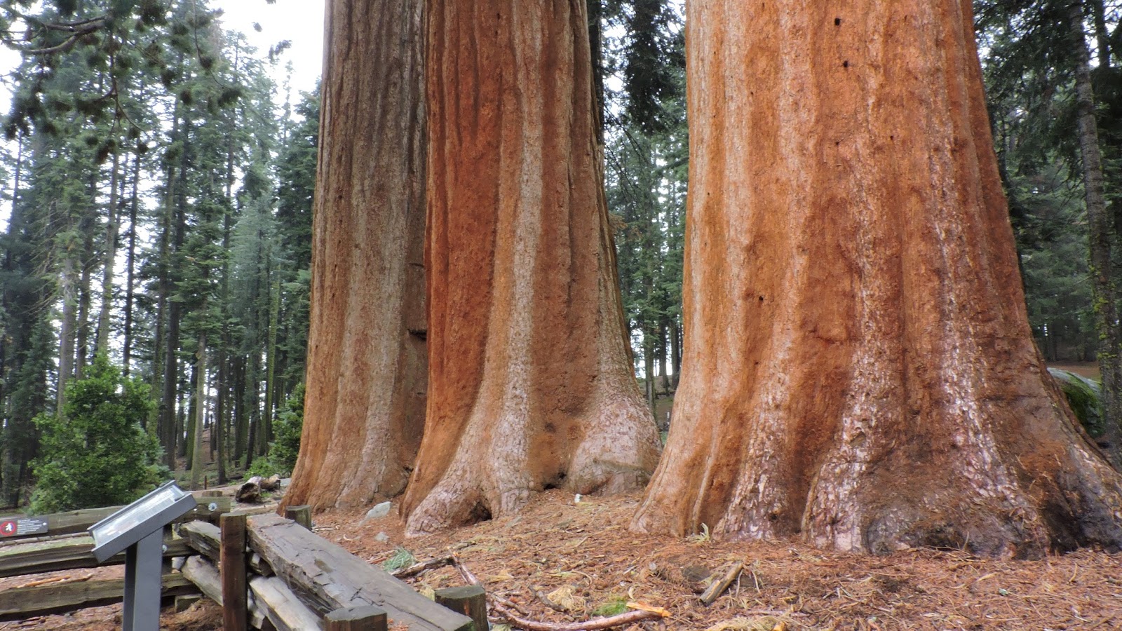
John is pleased to be getting back into the tall trees, too.


It's a wet snow and sticking to the trees in Christmas-like images.


We're beginning to wonder if we should put on the snow chains that we now carry with us everywhere.  Granpa's not excited about that idea, and besides it looks like we're now headed downhill into warmer weather - maybe.  I'm thinkin', uh, yeah, downhill !  It's a whole lot easier to slide off the side of a mountain when you're already headed downhill.  But, then again, there are some mighty big trees ready to catch us in their boughs...


From high winds blowing us all over the road on the way to Three Rivers, to the snowfall we're dealing with now, we move on to yet another weather extreme that I'll post about tomorrow.

Monday, May 11, 2015

Hospital Rock

On our way back to Three Rivers, across from a parking/picnic area, there is a place called Hospital Rock.  The guide map says that there are "exhibits about the Western Mono people who once lived here. A short trail built by the CCC leads to a cascade. Careful; drownings often occur here!  Always store food in the metal boxes provided to keep it from bears."  Death by drowning or being eaten by a bear.  This we gotta do!

Granpa hits the head while I try to find the short trail.  Walkin', lookin', lookin', walkin'.  Only one trail presents itself, and it's leading away from the river.  There's a road across the way, but the guide said "trail" not "road."  So we fuss at each other a bit and finally decide to walk a ways up the road to see if something presents itself.

Here's a cool thing.  Way cool.


This is a community kitchen dating back to 1350!  All the women from a village of about 500 people would gather here to grind their food! There would be wood to shape into bowls and use as utensils, fresh water from the river below, and tons of acorns from the surrounding trees to grind into meal on this rock - not to mention the shade from the hot summer sun.  It took a long time to grind acorns by hand, and having a community location allowed the women to visit and the children to play with friends.  You think graffiti is new?  These petroglyphs show that even way back then teenagers were into making their mark:


Directly across from the huge rock kitchen is Hospital Rock.


When Hale Tharp and John Swanson were exploring the Giants (Sequoias), and after a couple of injuries were treated here by friendly Indians in the 1860's, Tharp names it Hospital Rock.  In 1873, one James Everton was also treated here. He somehow managed to get in the way of a shotgun snare set to trap a bear.  Drowning, bear, gunshots - this is a pretty dangerous corner of the world!


But we explore farther in search of the CCC construction. Past the community kitchen we hear rushing water and work our way down to the underside of the "kitchen" rock.  (That is one big rock!)  Here we discover the CCC work.  Didn't they do excellent work for a bunch of 16-20 year olds?


From the top of the steps we look into the rushing water that we had heard from the kitchen up above.
If I hadn't been so stubborn about locating this we would have missed something special.  (A friend of mine once pointed out that there is very little difference between being stubborn and being patient.)


Pictures are nice - they help Granpa and I to remember what we saw - but there is nothing, absolutely nothing, like being there.  Look at the marbled rocks across the river.  You just have to be there to know how truly, amazingly beautiful this place is.  We did not see a bear.  We did not drown.  There were no gunshots.  There was no need for Hospital Rock.  (Whew!) A perfect end to a perfect day!


Sunday, May 10, 2015

Back to Three Rivers

It was pretty cold today - cold enough that I wish I'd brought my ski jacket instead of the lightweight one.  We had hoped that it would snow at least a few flakes, too.  But we've reached the time of day that we should turn around and head back to the hotel.  The hike up from General Sherman at 7,000 feet about did me in - and I think I noticed Granpa was just as happy for the rest stops as I was.

Being ready to head back does by no means the end of the picture taking.  My momma always said turning around simply shows you the views missed.  And so it is.

It seems that hot tubs were not invented recently.  I suspect that this one has been around for eons.


I don't know what individual parts of this photo I like best, but I certainly like the whole thing!  The rocks alone are exquisite!  God is amazing in the detail that He has put in our surroundings for no other reason that to amaze us.  Thank you, Lord!


Granpa has found a buck who's lost his horns over the winter, but if you look closely you can see them beginning to form again.


And the beauty just keeps coming.


Coming up next:  Hospital Rock

Saturday, May 9, 2015

Oh, Deer. I Took These Pictures

Look deep into the center of this photo that I took.


Here.  Let me help you.  See?  There's three of them.


Or is this better?  It's only one, but it's up close.  I love catching them licking their lips!


I don't know which shot I like the best, the first or the last.  I mean, the first shot is of the deer with their surroundings; the last is just the deer.  What do you think?


Friday, May 8, 2015

General Sherman - The Largest Tree in the World!


We are surprised by a plethora of Dogwood trees in bloom.  They are around every turn!


General Sherman is by no means alone up here.


Standing up or laying down, these trees are enormous.  Imagine a tree lying in your yard big enough to drive through.

These babies are even wide enough to use as one lane bridges - just drop it across a river and drive over!


We reach the location of the General Sherman. Where we parked 10 or 12 years ago is now designated handicap parking only.  The general public must keep on driving up and around until we arrive at a much larger parking lot.  From there we must walk back down to the General. Not bad, but ultimately we will have to trek back up - and we are at 7,000 feet above sea level.


And there he is, the Sequoiadendron giganteumBy volume, he is the largest known living single-stem tree on earth.  Now, to be perfectly honest, he is neither the tallest (that would be the Hyperion redwood on California's coast, nor is it the widest (cypress and baobab have greater diameters), nor is it the oldest.  (See our earlier post, http://www.thetravelerstwo.net/2014/12/the-methusaleh-tree.html Methusaleh is over on the eastern slopes of these Sierras in the White Mountain range.  That's not too far from here as the crow flies.) However, the General Sherman, with a height of 275 ft, a diameter of 25 feet, an estimated bole volume of 52,513 cu ft, and an estimated age of 2,300-2,700 years, is nevertheless among the tallest, widest and longest-lived of all trees on the planet.


If you were to uproot this guy (right after the National Park Rangers shot you dead), you could place it in the middle of a metropolitan highway, and it would block three lanes of traffic.  Or you could lay it on a Super Bowl football field and it would reach from one goal line to the opposite 9 yard line.  If it was even possible to get a set of balance scales big enough, you would have to get 10 blue whales to balance out the ol' General Sherman.

Spire tops, rounded tops and snag tops define at a glance the adolescent, mature, and elder Sequoia. Sherman is an elder so he has a snag top.  That means he's as big as he's gonna get, not getting enough nutrients to feed the top of his trunk, and is only feeding what he can.  But he still has many, many years to live.

As with the General Grant tree, all mention of exactly who the real General Sherman was has been removed from the interpretative signs, making me a not-happy camper. (See our earlier post: http://www.thetravelerstwo.net/2015/03/the-redwood-forest.html


Thursday, May 7, 2015

From Three Rivers into Sequoia National Park

This is the Kaweah Lake.  We pass it in the very short drive into Sequoia National Park.


But, if you're into trout fishing, keep driving.


Or just take a walk by the river.  It doesn't have to be all about the trees.


Again - just driving around America is utterly beautiful...


Through the tunnel of the past...


Until finally, after many hairpin turns, we go into the mist of ageless trees.


Past rivers and waterfalls,


Until finally we come out above the clouds ...


into the sunshine.


In the distance, a hundred miles away, we think we see the Pacific Ocean.  You'll probably need to be on a computer and not a smart phone to see it.  Then we find an interpretive sign that says that very thing - it really is the Pacific Ocean!


And finally we arrive.


Wednesday, May 6, 2015

Three Rivers, California and the Sequoia's

This trip will be through the southern tip of Nevada into California, around the southern tip of the Sierra's and up to one of the entrances into Sequoia and King's Canyon National Park.  The wind must be blowing 60 miles an hour!  Even though it's just a seven hour drive through the Mojave Desert gap, by the time we reach Three Rivers Granpa is exhausted from trying to keep us on the road. 
Three Rivers is a teensy-tiny town in the foothills of the Sierras.  Not surprisingly, the town is located near the junction of the North, Middle, and South Forks of the Kaweah River.  While Three Rivers is at about 1,000 feet above sea level, in less than 50 miles the mountains climb to 14,000 feet.  (Woo-hoo!)  Except for the coast line and the Central Valley, California is all mountains.

The scenery at Three Rivers is said to be almost identical to that of the Rhodesian kopje country.  So what, you ask.  Well, there was a group of folks who fought in the Boer Wars in Rhodesia that settled there in the late 1800's, and  some of them are buried here in the Pioneer cemetery.  The men fought in several wars in Rhodesia including the Boer Wars and World War I.  That's pretty different and interesting!


Doesn't this just make you want to get in your car and go!

Here's a big surprise:  One of those Rhodesian pioneers, Frederick Burnham taught woodcraft to Robert Baden-Powell of Paddington, England.  (Ever heard of Paddington Bear?)  Whoopee, you say.  Well, Robert, being inspired by what Burnham taught him, established - and is now known world-wide as the father of - the international scouting movement, and he was the first Chief Scout of the Boy Scout Association.  (He was also a lieutenant-general in the British Army.)  Overall, he is one very interesting dude - a man's man, but also an author and artist.  You should google him sometime:  http://en.wikipedia.org/wiki/Robert_Baden-Powell,_1st_Baron_Baden-Powell

Did you know that Nazism regarded Scouting as a dangerous espionage organization, and Nazi Germany banned Scouting in June 1934, seeing it as "a haven for young men opposed to the new State"? 

How'd I get off onto that rabbit trail?  Oh yeah, I was surprised by the Rhodesian-war fighters in the cemetery.  Well, back to the Sierra's...

John Muir came to this area in 1873.  He said that it was "a magnificent growth of giants...one naturally walked softly and awe-stricken among them.  I wandered on, meeting nobler trees where all are noble...this part of the Sequoia belt seemed to me the finest, and I then named it 'the Giant Forest.'"

Maybe, possibly - if you are on a computer and not a smart phone - you can get a sense in this next photo of what Muir was talking about.


Do you see the "Keep Right" sign?  to the right of it, halfway to the Sequoia, you will find Granpa. NOW do you get a sense of how monstrous these trees are?  And these are not the biggest of the big.


Tuesday, May 5, 2015

Arizona to the Tee


I think the Arizona desert is beautiful.  And I found the perfect blouse for camouflage, too, didn't I?
 
 
But I'm not the only one out here enjoying the beauty of Spring.  (Hurray for zoom lenses!)
 
 
 I love driving through the valleys.  I could do this day in and day out.


 The way up to the top of mountains is beautiful.
Granpa's contract has been extended.  Again.  I think we'll be putting this app to good use...


Monday, May 4, 2015

Arizona's Hummingbirds

Ever seen a hummingbird on it's nest?  Check these out - live, brought to you by the Desert Museum of Tucson, Arizona.  Remember the size of a hummingbird and, therefore, the size of this nest must be  pretty small!


 Or a white hummingbird?
 
 
(Golly I hope this is a photo Granpa took.  It downloaded from his phone.  No tellin' where he got it...  But the Hummingbird House at the Desert Museum was all aflutter with hummingirds!)